[ad_1]
CNN
—
Days after California was hit by “the most impressive storm in nearly 20 years,” the state – fully saturated in many places – is gearing up this weekend for yet another series of atmospheric river events, with flooding, hail, powerful wind gusts and even funnel clouds possible in spots.
Another round of heavy rain already is falling Saturday on the Golden State, where extreme drought fueled by the climate crisis has given way in recent weeks to massive flooding amid a catastrophic sequence of ultra-wet atmospheric rivers – long, narrow regions in the atmosphere that transport moisture thousands of miles. Recent storms have killed at least 18 people and left tens of thousands at a time without power.
Over 25 million people again are under flood watches across much of California’s central coastline, as well as the Sacramento and San Joaquin Valleys. Though this weekend’s rain tally will be lower than previous storms, the threshold for flooding also is much lower because the ground is fully saturated in many areas.
“This atmospheric river is more progressive than some of the other atmospheric rivers that have occurred in recent weeks, which should help to limit the extent of the flooding potential,” the Weather Prediction Center said. “All that being said, just about all of California; from the coast and both the Shasta and Sierra Nevada on south to the Transverse Range feature soil moisture percentiles greater than 95%.”
“Portions of the state have picked up 15-20+” of rain and >600% of normal rainfall in the last two weeks,” they added.
And unfortunately, the rain chances don’t end there: Yet another storm will bring renewed rain chances and flooding to much of the state Sunday afternoon through Monday morning before drier conditions finally set in later next week.
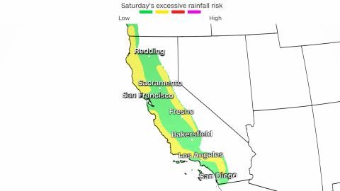
“A more intense surge of moisture is expected on Saturday ahead of a stronger Pacific storm system that will move inland through the day,” the prediction center said. “A broader slight risk of excessive rainfall is in place for both coastal northern California, where rainfall will continue from Friday, as well as upslope regions of the Sierra.”
Rain and snow are also forecast to spread into the Pacific Northwest and Intermountain West Saturday into Sunday.
Widespread rainfall totals through Monday will range between 2 to 3 inches along the coast and interior valleys, with 4 to 6 inches possible for the San Francisco Bay area and the nearby Santa Cruz and Santa Lucia mountains. This will likely lead to a few instances of flooding as well as mud, rock and landslides.
“Rain is a certainty with (rain chances at) 100% areawide and with deep moisture and ample rainfall expected, flooding once again becomes a concern,” the National Weather Service office in San Francisco said.
San Francisco already has recorded one of the top 15 wettest winters on record with more than a month to go. If it does end up picking up 4 to 6 inches of rain over the next three days, the city easily will crack the top five.
A slight risk of excessive rainfall – Level 2 out of 4 – alert is in place, mainly due to extremely wet conditions preceding the forecast rainfall and leading to increased flooding concerns.

“Forecast soundings have been showing quite a bit of instability over the Central Valley behind the front later Saturday afternoon and into the evening with hail likely to accompany stronger storms, and maybe some funnel clouds,” the weather service office in Sacramento said.
River flooding is also a big concern, especially around the Russian River in Northern California and the Salinas River near Monterey. “Plan on additional disruptions to travel and mountain recreation through the weekend as periods of heavy snow return to the Sierra,” the weather service office in Reno said.
Very heavy snow is also forecast for the Sierra, with 1 to 2 feet possible on Saturday and an additional 2 to 3 feet through Monday. “Heaviest snowfall days will be Saturday and Monday with less intense snow showers in between,” the weather service office in Reno said.
Strong winds will also accompany this system, gusting up to 40 to 50 mph in the Sacramento Valley and up to 60 mph in the mountains. This could lead to downed trees and power lines staked in now-extremely saturated soils.
“The system will be packing a decent amount of south winds and a high wind watch is in effect for the mountains of San Luis Obispo and Santa Barbara counties – the same strong winds will move into Ventura and LA counties Saturday evening,” the weather service office in Los Angeles said.
The good news is that by week’s end, the forecast calls for much drier conditions across all of California, which will allow for the ground to dry out and river levels to recede.
“It’s been a long time since California residents were happy to see an extended forecast of below-average precipitation,” CNN Meteorologist Brandon Miller said. “But after the past three weeks, they certainly are.”
Source link