[ad_1]
CNN
—
A massive cross-country storm is producing damaging tornadoes in the South, where a child has died, and punishing blizzard conditions in Colorado and the Plains that have resulted in shuttered interstates and snarled travel.
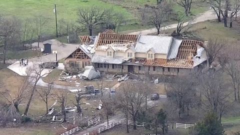
The storm system moving east across the nation – currently lingering over the central US – is fueling severe weather felt throughout the country, with at least five confirmed tornadoes in Texas and multiple others reported. The storms left a path of destruction across Oklahoma and the Dallas-Fort Worth area Tuesday, flattening homes and injuring at least seven people.
In Louisiana, a child who was missing after a tornado touched down in Keithville Tuesday was found dead, and a search for the young boy’s mother is ongoing, the Caddo Parish Sheriff’s Office said in a Facebook post.
“A young boy was found deceased in a wooded area of Pecan Farms where his home was destroyed,” the sheriff’s office said.
About 100 miles away in the small Union Parish town of Farmerville, Louisiana, at least 20 people were injured after a tornado struck Tuesday night, according to Farmerville Police Detective Cade Nolan.
“It’s the worst damage I’ve seen in 17 years,” Nolan told CNN, describing seeing mobile homes lifted from their axles and frames and in some cases carried a quarter of a mile away.
First responders were still searching for people in the early morning hours Wednesday, Nolan said, adding several people were injured while traveling in cars.
Meanwhile, nearly 10 million people – largely in the north-central US – are under winter weather warnings or advisories, with blowing snow and power outages a key concern. Another 6 million people across the northeast will be under winter storm watches Wednesday.
As the storm continues its trek east, here’s what different regions can expect:
- Tornadoes and damaging winds are possible Wednesday over parts of southern Louisiana, southern and central Mississippi, southern Alabama and the western Florida Panhandle.
- There is an enhanced risk of severe thunderstorms, and a risk of excessive rainfall over the Lower Mississippi Valley and Central Gulf Coast through Thursday.
- Heavy snow, rain and freezing rain are expected over the Upper Midwest Wednesday
- Freezing rain and sleet are expected to continue across the Plains and then shift into the Upper Midwest through Wednesday, making travel dangerous.
The storm over the Central Plains is expected to move northeast to the Upper Great Lakes, while a sister storm develops over parts of the Mid-Atlantic by Thursday, according to the Weather Prediction Center. Multiple days of heavy snow, strong winds and freezing rain will continue to stir up extreme weather across the north-central US through Thursday evening.
More than 3 million people across parts of Louisiana, Texas, Mississippi, and Arkansas were under tornado watches early Wednesday. The main threats continue to include possible tornadoes, hail and gusts up to 75 mph.
Since Tuesday, there have been multiple tornado and hail reports.

Videos showed downed power lines and destroyed homes in Decatur and Blue Ridge, Texas, as well as Wayne, Oklahoma, after the storm brought severe weather barreling through.
Just outside Dallas, storms left at least five people injured, Grapevine police said. Businesses including a Grapevine mall, a Sam’s Club and a Walmart were damaged, police said.
Another two people were injured, and homes and businesses were damaged, in Wise County Tuesday morning, northwest of Fort Worth, county officials said. One person was hurt when wind overturned their vehicle, and the other – also in a vehicle – was hurt by flying debris, officials said.

In Wayne, Oklahoma, a confirmed EF2 tornado knocked out power and damaged homes, outbuildings and barns early Tuesday, officials said, though no injuries were reported.
In Farmerville, Louisiana, Tiyia Stringfellow told CNN she was inside her apartment when a tornado hit. She was with her boyfriend and two young children and all of them survived without injuries, she said.
“We were in the kitchen closet,” Stringfellow said. “All we heard was whistling and my boyfriend got up to look outside of the window and he (saw) the tornado, the whole house was shaking and I (saw) my roof cave in and the house went dark.”
For Wednesday, parts of southern Louisiana, southern and central Mississippi, southern Alabama and the western Florida Panhandle still face an enhanced threat of severe weather.
Cities like New Orleans and Baton Rouge in Louisiana and Mobile, Alabama, could see a few strong tornadoes, damaging winds and large hail.
The storm could also bring isolated tornadoes, hail, and damaging winds to the area from the Texas-Louisiana border to the Panhandle of Florida north to central Mississippi, Alabama, and western Georgia.
By Thursday, the threat weakens to a slight risk for severe weather as the storm moves towards the East Coast.
Blizzard conditions in the Northern and Central High Plains are expected to make travel dangerous on snow-covered roads amid 1-2 inches per hour snow rates and winds gusting at 50-60 mph, according to the Storm Prediction Center.
The “one-in-five-year storm” worked its way through parts of Nebraska Tuesday and is expected to linger in the area through the end of the week, NWS metrologist Bill Taylor said.

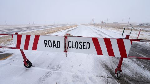
Blizzard warnings are in place throughout parts of the state and the state’s Department of Transportation said several roadways are closed, including all roadways from Nebraska into Colorado.
Residents will be contending with near zero visibility making travel difficult, as well as possible scattered power outages.
In South Dakota, schools in the Rapid City area closed Tuesday and will remain shuttered on Wednesday due to the snow conditions in the area, the school district said on Facebook.
The wintry weather conditions caused a closure of both east and westbound lanes of Interstate 90 from Rapid City to the Wyoming state line on Tuesday, state transportation officials said.
Heavy snow and gusty winds will likely spread across the Northern Plains into the Upper Midwest Wednesday and Thursday, the Storm Prediction Center said.
Freezing rain and sleet are expected to continue across the Plains and then shift into the Upper Midwest through Wednesday, again making travel dangerous.
“Strong winds and cold temperatures will continue even after this storm ends, creating bitterly cold wind chills,” the National Weather Service said.
As the second storm develops over the Southern Appalachians and moves to Mid-Atlantic on Thursday, residents can expect heavy snow over parts of the Lower Great Lakes, Central Appalachians and the northern Mid-Atlantic.
Source link


